↓
 

Pelham Land Surveying

Pelham Land Surveying
  • Home
  • ALTA Title Survey
  • Boundary Surveying
  • Construction Surveying
  • Drone LiDAR Mapping
  • Elevation Certificate
  • Land Surveying
  • Topographic Survey | Topo Survey
  • Blog
  • Contact Us
Home

How to Read a Land Survey

Pelham Land Surveying Posted on May 25, 2026 by Pelham SurveyorMay 21, 2026
Property owner reviewing a land survey map and property details on a laptop while checking boundary information

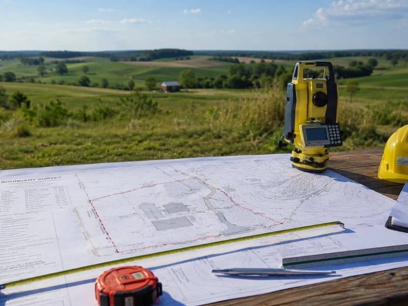
Buying land or planning a project often comes with a lot of questions. Where exactly are the property lines? Can you build a fence near the edge of the lot? Does that driveway belong entirely to you? Is there anything hidden on the property that could affect future plans?

Many property owners receive a survey and look at it like it is written in another language. There are lines, symbols, measurements, and notes scattered across the page. At first glance, it can feel confusing.

The good news is that you do not need to be a surveyor to understand the basics.

Learning how to read a land survey can help you make smarter decisions before buying, selling, building, or improving property. It can also help you spot issues early and avoid expensive surprises later.

Why Property Owners Should Learn to Read a Survey

A land survey can answer questions before problems happen.

People often assume a fence marks a property line. Others think a tree line or driveway creates a boundary. Sometimes those assumptions are wrong.

Knowing how to read a survey can help property owners:

  • Understand legal property limits
  • Plan future projects
  • Avoid boundary mistakes
  • Identify restrictions
  • Spot possible issues before construction begins

For example, someone planning a workshop or pool may think there is enough space. Then the survey reveals utility easements or setback restrictions that reduce the buildable area.

Learning to read the survey first can prevent frustration later.

What Information Is Shown on a Land Survey?

Most surveys include several key elements. Understanding these parts makes the document easier to read.

Look for:

  • Property lines
  • Distances and dimensions
  • Bearings and directional information
  • Easements
  • Existing structures
  • Property corners
  • Rights-of-way
  • Survey notes

Not every survey contains the same information. Some surveys focus only on boundaries, while others include more details depending on the project.

Start With the Title Block

To read a land survey, start with the title block, property description, north arrow, scale, boundary lines, and legend. Then review measurements, easements, structures, and notes. If something affects ownership, access, or construction, ask a licensed surveyor to explain it before making decisions.

Most surveys have a title block near the top or bottom of the page.

This section often includes:

  • Property owner information
  • Survey date
  • Property address
  • Survey type
  • Survey company information
  • Legal description reference

Think of the title block as the survey’s introduction. It gives context before you review the map itself.

Understand Property Lines and Boundaries

Property lines show the legal limits of a parcel based on records, field measurements, and survey evidence. They may not match fences, trees, driveways, or online maps. A survey helps confirm where the land begins and ends so owners can avoid boundary mistakes.

Boundary lines are usually one of the most important parts of a survey.

These lines define the legal edges of the property.

Along the boundary, you may see:

  • Measurements
  • Distances
  • Angles
  • Bearings
  • Property corner markers

You may also notice labels identifying monuments or markers found during field work.

Keep in mind that physical objects do not always match legal boundaries.

A fence can sit several feet inside a property line. A driveway may cross onto neighboring land. Looking at the survey helps clarify what actually exists.

Learn Common Survey Symbols and Abbreviations

Survey maps often use abbreviations to save space.

Some common examples include:

SymbolMeaning
R/WRight-of-way
POBPoint of Beginning
EasementArea with shared legal use rights
SetbackRequired distance from property line
IPFIron Pin Found
IPSIron Pin Set

These labels help surveyors communicate large amounts of information in a smaller space.

Most surveys include a legend that explains symbols and line styles. Review this section before assuming what markings mean.

What Easements Mean on a Survey

Easements are areas where another party may have the legal right to use part of the property. Utility companies, neighbors, or public agencies may hold easement rights. These areas can limit where owners build fences, driveways, additions, or other improvements.

Easements often surprise property owners.

Someone may believe they own and control every square foot of land. Then they discover utility access rights running through part of the lot.

Common easements include:

  • Utility easements
  • Drainage easements
  • Shared access easements
  • Public access areas

These locations may affect future plans.

Always review easements before starting construction projects.

When Should You Ask a Surveyor for Help?

A property owner should ask for help when a survey shows easements, encroachments, unusual boundaries, flood notes, access issues, or unclear measurements. A licensed surveyor can explain how these details may affect buying, building, selling, or improving the property.

Some surveys are straightforward.

Others become more complicated.

Questions often come up when:

  • Structures cross boundaries
  • Easements appear near planned construction
  • Measurements seem unclear
  • Property corners cannot be located
  • Access rights affect land use

Professional guidance can help prevent mistakes.

Understanding a Survey Starts With Asking Questions

A land survey can look complicated at first. Once you understand the basic parts, the information becomes much easier to follow.

Learning how to read a survey helps property owners move forward with more confidence.

Whether you are buying land, planning improvements, or preparing for construction, understanding the details of a survey can help you avoid confusion and make better decisions.

Good property decisions begin with accurate information.

Frequently Asked Questions

Can I use online maps instead of a survey?

Online maps can provide a general reference, but they may not have survey-level accuracy.

Do fences always show the property line?

No. Fences are not always built directly on legal boundaries.

Are all surveys the same?

No. Different survey types provide different information depending on the purpose.

Can easements affect construction plans?

Yes. Easements can limit where structures or improvements can be placed.

Should I ask questions about my survey?

Yes. If anything appears unclear, speaking with a licensed surveyor can help avoid misunderstandings.

Posted in land surveying | Tagged land surveying

Types of Land Surveys Explained for Property Owners

Pelham Land Surveying Posted on May 22, 2026 by Pelham SurveyorMay 21, 2026
Surveying tools and property maps placed outdoors overlooking open land during a site planning and boundary survey project

Buying property or planning a project often brings up one big question. What type of survey do you actually need?

Many property owners hear terms like boundary survey, topographic survey, or ALTA survey and assume they all do the same thing. They do not. Each survey is designed for a different purpose and answers a different set of questions.

Choosing the right survey early can help avoid delays, confusion, and extra costs later. The key is understanding what each one does and when it is used.

What Are the Main Types of Land Surveys?

Land surveys come in different forms depending on the goal of the project. Some focus on legal boundaries. Others gather information for construction, development, or property transactions.

Below are some of the most common survey types property owners may encounter.

Boundary Survey

A boundary survey identifies the legal limits of a property using records, measurements, and field evidence. Property owners often use this survey before installing improvements, handling ownership questions, or preparing land for future changes.

A boundary survey focuses on determining where a property begins and ends.

Surveyors review deeds, historical records, and field evidence to locate property corners and legal boundary lines.

Property owners often request boundary surveys when:

  • Installing fences
  • Planning additions
  • Purchasing land
  • Resolving property questions
  • Preparing for future improvements

Not every property line is visible from the ground. Features that appear to mark boundaries are not always accurate.

According to the U.S. Bureau of Labor Statistics, surveyors collect precise measurements used for property boundaries and construction planning.

Topographic Survey

A topographic survey maps land features and elevation changes. It helps designers and builders understand how land slopes, drains, and changes across a property before planning future work.

Unlike a boundary survey, a topographic survey focuses on the shape of the land.

This type of survey may identify:

  • Elevation changes
  • Slopes
  • Trees
  • Drainage paths
  • Existing structures
  • Surface features

Topographic surveys are commonly used before:

  • Site design
  • Drainage planning
  • New construction
  • Engineering work
  • Development projects

Even land that looks flat may contain changes that affect future work.

The U.S. Geological Survey explains that topographic mapping uses elevation information to show the shape and surface features of land.

ALTA/NSPS Land Title Survey

An ALTA/NSPS Land Title Survey provides detailed property information used during commercial real estate transactions. It follows national standards and often includes boundaries, easements, access information, and additional requested items.

This survey is usually associated with commercial property transactions.

Lenders, attorneys, title companies, and developers often request this survey because it provides more detailed information than standard surveys.

An ALTA survey may include:

  • Property boundaries
  • Easements
  • Access information
  • Rights of way
  • Improvements
  • Selected Table A items

National standards guide how these surveys are completed and documented.

Construction Survey

A construction survey helps place proposed improvements in the correct location before or during construction. It translates plans into physical points on the ground.

Builders use construction surveys to transfer design plans from paper to the site itself.

This process helps position:

  • Buildings
  • Roads
  • Utilities
  • Foundations
  • Site improvements

Without accurate layout information, mistakes in placement can create expensive corrections later.

Subdivision Survey

A subdivision survey divides a larger property into smaller lots while following local requirements and regulations.

Property owners sometimes want to create additional lots from a larger tract of land.

Subdivision surveys help establish:

  • New lot lines
  • Access points
  • Easements
  • Plat information
  • Legal descriptions

Local approval requirements often play a role in this process.

Elevation Certificate

An elevation certificate documents a property’s elevation information for flood-related purposes and insurance requirements.

Properties located near flood-prone areas sometimes require elevation documentation.

This information can support:

  • Flood insurance
  • Floodplain evaluations
  • Risk assessments
  • FEMA-related documentation

This survey type focuses on elevation data instead of ownership boundaries.

How Do You Know Which Survey You Need?

Many people choose a survey based on price alone. That approach can create problems.

Instead, start with the purpose of the project.

Here is a simple guide:

SituationRecommended Survey
Buying commercial propertyALTA survey
Designing a siteTopographic survey
Building improvementsConstruction survey
Dividing larger landSubdivision survey
Flood-related requirementsElevation certificate
Clarifying legal limitsBoundary survey

The right survey depends on what questions need answers.

Why Choosing the Correct Survey Matters

Choosing the wrong survey type can create delays, leave out important information, and increase costs during a project.

Not every survey gathers the same information.

Ordering a survey that does not fit the project can create issues such as:

  • Missing site details
  • Delayed permits
  • Extra field work
  • Additional costs
  • Incomplete project planning

Property owners often focus on getting a survey quickly. A better approach is making sure the survey matches the goal.

The right information early often saves time later.

Frequently Asked Questions

Are all land surveys basically the same?

No. Different surveys focus on different goals. Some identify legal boundaries while others gather site, elevation, or development information.

Which survey is most common for homeowners?

Boundary surveys are often requested by homeowners planning property improvements or preparing for future projects.

Can a survey serve more than one purpose?

Sometimes. Certain projects may require multiple survey types depending on the work involved.

Who determines which survey is needed?

The project itself usually determines the survey type. A licensed surveyor can help identify the right option.

Should I order a survey before planning a project?

Starting early often helps prevent delays and allows property decisions to be made using accurate information.

Posted in land surveying | Tagged land surveying

What Land Surveying Means for Your Property

Pelham Land Surveying Posted on May 21, 2026 by Pelham SurveyorMay 22, 2026
Land surveying work in progress as a surveyor measures a residential property to identify property boundaries

Buying land or owning property comes with important questions. Where does your property start? Where does it end? Can you build where you want? Are fences and structures in the right place?

Many people think they know their property lines. Then a project begins and surprises appear.

That is where land surveying comes in.

Land surveying gives property owners a clearer picture of their land. It turns guesses into facts. Before making major decisions, a survey can help you understand what you own and what may affect your plans.

What Is Land Surveying?

Land surveying is the process of measuring and mapping land. A licensed surveyor studies property records, takes field measurements, and creates documents that show important details about a property.

Land surveying helps define:

  • Property boundaries
  • Property corners
  • Existing structures
  • Access areas
  • Easements
  • Site features

Surveyors use specialized equipment and records to collect accurate information. Their work creates a reliable picture of the property’s layout.

The Bureau of Labor Statistics explains that surveyors make precise measurements to determine property boundaries and prepare land information used in construction and development.

While maps and county records can provide general information, they are not always enough for important decisions.

A survey gives documented measurements that can be relied upon.

Why Property Owners Often Run Into Problems

Many property issues start because people assume things.

A fence may look like a property line. A row of trees may seem like a boundary marker. A driveway may appear to belong entirely to one property owner.

Sometimes those assumptions are wrong.

Imagine buying a home and later discovering that a shed crosses into a neighboring lot. Or imagine building a new garage only to learn that it sits too close to a property line.

Problems like these can create stress, extra costs, and legal issues.

A survey helps uncover facts before problems grow larger.

What a Survey Can Reveal About Your Property

Land surveys do more than place lines on paper.

They often reveal details that property owners may not know exist.

A survey may identify:

  • Boundary locations
  • Easements for utilities
  • Encroachments
  • Shared access areas
  • Existing structures
  • Site conditions that affect future plans

For example, utility companies sometimes have legal rights to access portions of a property. These areas are called easements.

A homeowner may believe they can build anywhere on their lot. Then a survey shows that utility access rights limit certain areas.

Learning this information early can save time and money.

Why Survey Information Matters Before Making Changes

Property improvements often seem simple at first.

Maybe you want to install a fence. Build a workshop. Add a pool. Expand a driveway.

Projects become more difficult when property details are unclear.

Building without accurate information creates risk.

A small mistake in placement can create large issues later.

Survey information helps property owners make better decisions before construction begins.

Instead of asking, “I think this fits here,” you can say, “I know where this belongs.”

That confidence matters.

Common Situations Where Surveys Help

Many people think surveys are only for large commercial projects.

In reality, surveys are useful during everyday situations.

Property owners often order surveys when:

  • Purchasing land
  • Selling property
  • Planning home improvements
  • Dividing land
  • Solving neighbor concerns
  • Preparing for construction projects

Commercial property owners also rely heavily on surveys because lenders, title companies, and developers often require accurate land information.

In many situations, surveying becomes part of the planning process long before work begins.

Understanding Why Professional Accuracy Matters

Property ownership involves legal rights. Because of that, accuracy matters.

A licensed surveyor follows professional standards and uses field evidence, measurements, and records to support findings.

Surveyors do not simply estimate locations.

They investigate:

  • Existing records
  • Deeds
  • Historical information
  • Physical evidence found on-site
  • Measurements collected in the field

This process helps create a more dependable result.

Even properties that seem simple can contain details that are not obvious from looking at the land.

A Better Understanding of Your Property Starts With Facts

Owning property should come with confidence.

Whether you own a home, vacant land, or commercial property, understanding what exists on your site matters.

Land surveying helps replace uncertainty with information.

Before building, buying, selling, or planning changes, having accurate property data can help avoid unnecessary problems.

Good decisions start with good information.

For many property owners, a survey becomes one of the first and most important steps in understanding what their property truly means.

Frequently Asked Questions

Does a fence show the actual property line?

Not always. Fences are sometimes installed inside or outside legal boundaries. A land survey provides a more accurate answer.

Can I rely on online property maps?

Online maps are helpful for reference, but they often do not provide survey-level accuracy.

Do small residential properties need surveys?

Yes. Even smaller lots can have boundary questions, easements, or site issues that affect future plans.

Is surveying only used before construction?

No. Surveys are also used during property sales, land divisions, and ownership questions.

Why hire a licensed surveyor?

Licensed surveyors follow professional standards and provide documented information that can support legal and property decisions.

Posted in land surveying | Tagged land surveying
Get Quote Button
Order an ALTA Survey Pelham AL
© 2020 Pro17 Engineering, LLC
PelhamLandSurveying.com
Address: Pelham, Alabama
Phone: (205) 406-8178

Web Development and SEO by:
N2Biz.co


Privacy Policy | Terms of Use

&nbsp Privacy Policy
↑